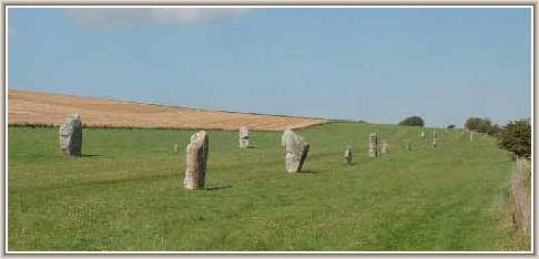
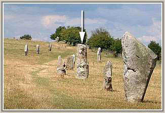
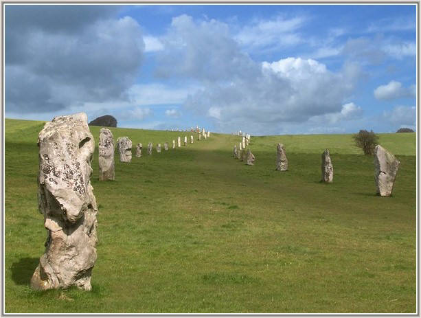
Like the stones of the cove those of the avenue are of male and female types and had been deliberately erected in pairs with a male stone facing a female stone and vice versa along the length of the avenue. Female stones are crudely diamond shaped, male stones are more pillar-like.
The West Kennet Avenue connects the south entrance of the Avebury Henge to the Sanctuary one and a half miles away on Overton Hill. The avenues were the last components of the henge to be constructed at around 2400 BC. That of the West Kennet is believed to have consisted of about 100 pairs of stones spaced at intervals of 80 feet with the avenue being about 50 feet wide throughout much of its length though it may have narrowed as it approached the Sanctuary. As in common with the rest of Avebury many stones were to be buried and many destroyed. The stones varied quite considerably in size between 4 and 13 feet high. John Aubrey recorded it as being fairly complete but when Stukeley visited it he found only 72 stones so much of its destruction was already taking place. By the time Alexander Keiller arrived on the scene only 4 remained standing.
It was to be Keiller's excavations and subsequent restoration of what surviving stones he found that has provided us with the spectacle we see today. Even with so many of the stones now lost the appearance of the avenue still impresses. He discovered that there was evidence of burials at the base of some of the stones. These were associated with the Beaker Folk who were coming into Britain from the continent during the late Neolithic period and with the advent of the Bronze Age.
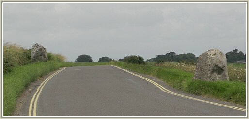
As well as the restored section of the avenue there are two more prominent stones either side of the road on the way to West Kennet and another four have survived on the lower slope of Overton Hill much nearer to the Sanctuary. The more adventurous visitor will find these to the south of the A4 road a short way from the turning to East Kennet. Three stones on the other side of the road are also believed to belong to the avenue.
If you visit Avebury from the east via the A4 and the West Kennet turn-off your first real sight of the Avebury stones will be the West Kennet Avenue. Although their numbers are much depleted they still make a wonderful introduction to the rest of the monument as you wonder how many feet and to what purpose have trodden the path they create.
The West Kennet Avenue viewed from the south.
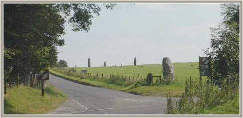
The Avenue disappears over the skyline when viewed from the circle.
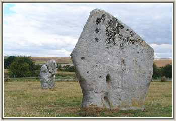
A typical sexual pair of stones in the Avenue
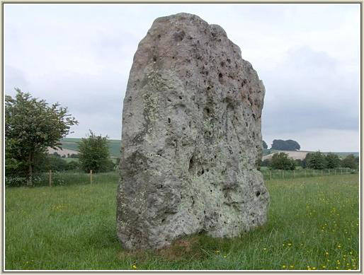
The controversial stone number 33a is a large "female" type to be found in the more southerly section of the restored avenue. The staining is visible as a reddish area at the top of the stone.
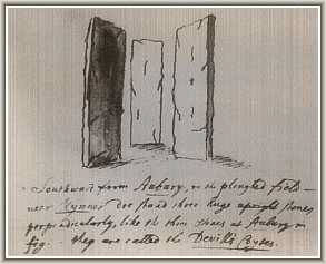
Aubrey's drawing of the cove believed to have once existed in the avenue
CLICK BUTTON for William Stukeley's
illustration of the West Kennet Avenue
CLICK BUTTON for William Stukeley's
illustration of the avenue entrance
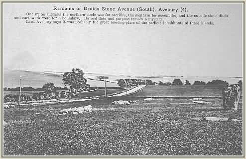
Old postcard view of the Avenue circa 1900
A number of holes and pits have been found mid-way along the avenue. These were originally thought to have been evidence of a settlement but are now believed to be the remains of a ritualistic site that had existed centuries before the avenue was built. A curiosity in this area is that there is no evidence that Stone 30b ever existed. Keiller was unable to find any sign of a stone hole at its assumed position.
Aubrey recorded three stones of a cove in the area where the modern road now interferes with the course of the avenue. They were also mentioned by Stukeley who referred to them as the "Devill's Coyts". However, some doubt remains as to whether Stukeley actually saw these stones himself and their existence has yet to be confirmed by modern researchers. Unfortunately the difficulties posed by their assumed location makes any such confirmation unlikely in the foreseeable future. The fact that the Beckhampton Avenue contains a cove implies that they may have been important components of both avenues. Uncertainties regarding the correct route and composition of the avenue still prevail. Since Keiller's restoration more recent surveys and excavations have attempted to resolve some of these issues as the extract below reveals.
The avenue appears to have been constructed in a series of short straight lengths. Its course as it leaves the South Entrance swings abruptly to the right and then to the left before it makes its way over the horizon towards the Sanctuary. It has that been suggested that this apparently deliberate "chicane" was a device to help make the entrance to the Henge appear more dramatic by introducing an element of surprise to anyone approaching along the avenue. It is easy to forget that the bank is now very mutilated and much reduced in height. When the avenue was in use it is almost certain that the interior of the Henge was totally obscured by the mighty earthwork that originally existed either side of the massive stones at the entrance..
The stone designated 33a in the avenue has become the subject of some controversy after it was re-erected by a team of workers under the direction of Mrs Maud Cunnington in 1912. When Alexander Keiller acquired the land 20 years later he deduced it had been restored in the wrong position and moved it by about 2 metres. He also decided that Mrs.Cunnington had erected it the wrong way up so he inverted it. From the evidence of staining visible on the stone modern researchers have now concluded that the Cunnington orientation was correct after all. Keiller's placement of it, though, is accepted as the accurate one......it might therefore be considered a case of an archaeological draw !! (As yet there are no plans to make any change).

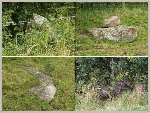
Roadside stones of the West Kennet Avenue
Four stones of the Avenue can still be found by the hedgerow on Overton Hill
CLICK BUTTON for plan of Alexander Keiller's
restoration of the avenue (includes stone numbers).
CLICK BUTTON for plan of the avenue
at West Kennet (includes stone numbers).
"Ucko and his collaborators conducted a resistivity survey to find the form and direction of the avenue beyond the section restored by Keiller. Today it ends abruptly at a fence separating the avenue from farmland. By plotting changes in the electrical resistance of the soil, they hoped to find where sockets for stones had been dug or to discover buried stones. They managed to plot the course of the avenue for a farther 150 metres southwards, but beyond that distance the evidence was inconclusive. Questions concerning the existence of a cove in Kennet Avenue, and whether one was supposed to walk between or outside the stones, either from Avebury to the Sanctuary, vice versa, or both, remain unanswered."
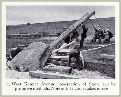
Keiller's men doing it the hard way !
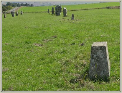
This truncated block differs from the usual plinths Keiller used to show the position of missing stones because it marks the estimated position of the elusive Stone 30b evidence of which has never been found.
This vision of an intact avenue is from Nicholas Mann's book "Avebury Cosmos"....courtesy of Nicholas Mann